
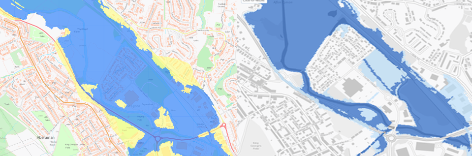
Take a close look at these two NRW flood maps of Aberaman.
The older map clearly shows large sections of the Aberaman floodplain highlighted as high-risk flood zones.
But in the latest version, much of that same area—now heavily developed—has mysteriously lost its flood-risk status.
It’s hard not to notice the difference.
So, the question is: where is all that water supposed to go now?
As more of Aberaman’s natural floodplain disappears under tarmac and housing, the risk doesn’t vanish; it simply shifts. Every missing blue zone on the map is water that will end up somewhere else, and recent flooding across Aberaman, Aberdare and Mountain Ash shows exactly where.
Another reason why local residents are right to keep asking: who’s really responsible for managing flood risk in the Cynon Valley?
Following on from our previous report “Neglected River Cynon Raises Flooding Fears Again: Who’s Responsible?”, we have again contacted Councillor Ann Crimmings, Cabinet Member for Environment and Leisure, to ask what action is being taken to address the continued neglect of the River Cynon.
Residents have repeatedly raised concerns about fallen trees, collapsed riverbanks, and blocked channels—issues that clearly increase the flood risk for homes and businesses. Under riparian ownership rules, the landowner of each section of riverbank is responsible for maintaining the watercourse and ensuring the free flow of water. After Storm Dennis and more recent severe weather events, you would think that coordination between the council and Natural Resources Wales (NRW) would be a priority.
The council’s reply:
🟥 “To provide you with some context, the River Cynon is considered a Main River. Therefore, where the relevant Risk Management Authority responsible for managing flood risk posed from Main Rivers is that of (NRW).”
🟥 “Whilst the Council is identified as the Lead Local Flood Authority (LLFA) that role does not extend to managing the risk of flooding from the main rivers. Where concerns around the flood risk posed from a Main river is concerned all correspondence should be referred to NRW to consider.”
🟥 “In respect of RCT’s Riparian responsibilities you are correct in that the Council is responsible for; the free flow of water through sections of the Main River where the Council has landownership that encompasses or borders the river(s). This ownership can extend to the central point where the river has two separate owners at either side of the channel.”
🟥 “Notably however, that role does not extend to considering interventions to manage the risk of flooding from the main river or an overarching role for sections of the river not within the Council’s control. As discussed above, any concerns around the flood risk posed by the Main River should be reported to NRW.”
However, council records show this is not the whole picture. According to a Freedom of Information request, the Council spent £130,000 of public money on riverbank repairs carried out on land not owned by the authority. The works were described as “non-prejudicial” and undertaken “in agreement with the landowner,” but the identity of that landowner remains undisclosed. The repair site lies only a few metres from the uprooted trees currently blocking the river near the Coed Dyffryn development in Aberaman.
New Council Report Highlights Ongoing Flood Risks in Aberaman
Rhondda Cynon Taf Council has now published its Section 19 Flood Investigation Report into Storm Bert (23–24 November 2024), providing new evidence of the challenges facing Aberaman and the River Cynon.
The report confirms that the main sources of flooding during the storm were “significant overland runoff from the steep hillsides above Aberaman” and the “overtopping of unnamed ordinary watercourses” that became overwhelmed and flooded several properties.
Although the investigation found “no evidence to suggest that the River Cynon significantly contributed to the recorded flooding of properties”, it noted that river levels reached 2.148 metres at Aberdare—more than three times the normal level—and likely “influenced the outfall conditions of culverted watercourse, surface water and sewer structures.”
This means that while the main river may not have been the direct cause, its high water levels still worsened the impact of flooding by restricting how well the smaller drains and culverts could discharge water.
This new evidence reinforces residents’ concerns: that fallen trees, debris, and reduced maintenance along the River Cynon contribute to the cumulative flood risk. Despite repeated flooding events and previous public expenditure, there appears to be no clear coordination between RCT Council and NRW over who is responsible for keeping this key section of river safe.
(Full Storm Bert report available here: RCTCBC Flood Investigation Report – Aberaman)
As we said, we also wrote to NRW regarding ongoing flooding in Aberaman, which is becoming increasingly severe due to the frequency of storms and heavy rainfall.
NRW’s reply:
🟩 “We are aware of a recent flood issue affecting commercial properties at Aberaman. The flooding was believed to be the result of a surcharged highway drainage system, which became overloaded during a high rainfall event, and is being dealt with by the local authority, Rhondda Cynon Taf.”
🟩 “While we endeavour to provide help and support to all local government authorities across Wales, our permissive powers are restricted to be used in the management of flood risk associated with main rivers.”
🟩 “We do not currently have any active incidents where our operational staff have been asked to remove obstructions at this location. I would be grateful if you could forward the details of any recent incidents where trees are currently forming an obstruction to flow which result in an increase in flood risk. Once this information is received, we will assess the need or not of removing such trees.”
A4059: Flooding Continues Despite Costly Works
Flooding on the A4059 has become almost inevitable following the infilling of the Aberaman Floodplain, approved by both RCT Council and NRW. Despite £500,000 spent on flood-alleviation measures along just 400 metres of road, the route remains one of the most flood-prone in the Cynon Valley.
We put this to NRW: repeated flooding has previously breached residential properties in Aberaman. The current situation is escalating, worsened by the loss of natural floodplain now built over with council approval.
🟩 NRW responded: “Surface water flooding to the A4059 is a matter for the local highway authority for the area, which is Rhondda Cynon Taf Local Authority. … The reduction of the indicative floodplain is of grave concern to NRW, and we are one of several statutory consultees that are able to provide comment with respect to planning applications put before the Local Authority Planning Department.”
🟩 “The planning process in Wales is governed by the policies contained within Planning Policy Wales (PPW) … As part of this framework, NRW is able to provide opinion of the flood risk to a particular area. We are not able to endorse or reject a planning submission. It is a matter for the local authority’s Planning Department and Planning Committee as to whether to approve or refuse a planning submission.”
We have again written to Councillor Crimmings and RCT Council requesting an internal review, having received no response to our last correspondence. The Information Commissioner’s Office (ICO) has also been informed that questions remain unanswered.
After years of costly flood defences and repeated warnings, it appears that the lessons of past flooding in Aberaman remain unlearned. The Council continues to approve development on known floodplains, while responsibility for maintenance of the River Cynon still drifts between RCT Council and NRW, with the local community left to pay the price.
Read the Storm Bert Flood Investigation Report →
Original coverage: Coed Dyffryn – Cwmbach
Related Posts

Flood plans should touch on surface risks, councils told. What about Rhondda Cynon Taf Council?
Ongoing inconsistencies of Applications and Deprivation of Liberty Safeguards for authorisations (DoLS) Across Wales, report finds

South Wales Police made multiple arrests following a report of a burglary ongoing in a unit on Hirwaun Industrial Estate.