DOWLAIS TOP TO HIRWAUN DUALLING AND SLIP ROADS
THE WELSH MINISTERS (THE NEATH TO ABERGAVENNY TRUNK ROAD (A465) (ABERGAVENNY TO HIRWAUN DUALLING AND SLIP ROADS) AND EAST OF ABERCYNON TO EAST OF DOWLAIS TRUNK ROAD (A4060) AND CARDIFF TO GLAN CONWY TRUNK ROAD (A470) (CONNECTING ROADS) (DOWLAIS TOP TO HIRWAUN)) (SUPPLEMENTARY) (NO.1) COMPULSORY PURCHASE) ORDER 2020
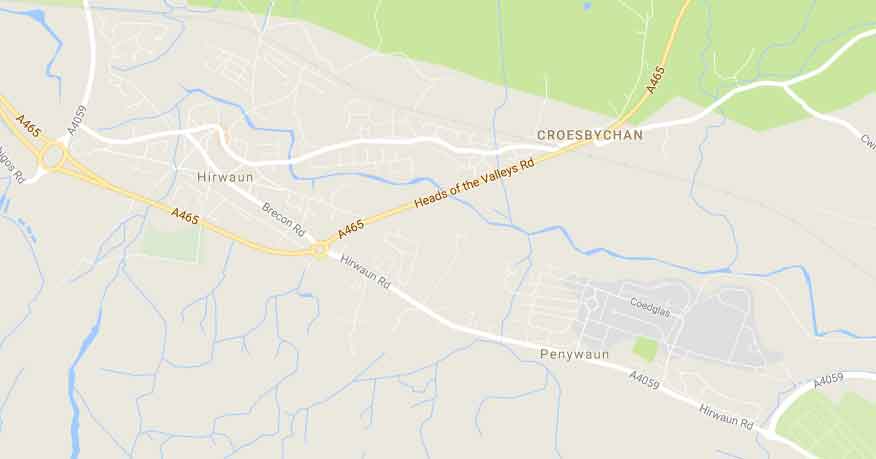
COMPULSORY PURCHASE OF LAND AND NEW RIGHTS BETWEEN DOWLAIS TOP AND HIRWAUN
THE WELSH MINISTERS have made “The Welsh Ministers (The Neath to Abergavenny Trunk Road (A465) (Abergavenny to Hirwaun Dualling and Slip Roads) and East of Abercynon to East of Dowlais Trunk Road (A4060) and Cardiff to Glan Conwy Trunk Road (A470) (Connecting Roads) (Dowlais Top to Hirwaun)) (Supplementary) (No. 1) (Compulsory Purchase) Order 2020”, under sections 239, 240, 246, 250 and 260 of the Highways Act 1980 and under section 2 of, and paragraph 1(1)(b), (3) and (4) of Part 1 of Schedule 2 to, the Acquisition of Land Act 1981. The Welsh Ministers have made this Supplementary Compulsory Purchase Order, together with the Compulsory Purchase Order that was made on 17 April 2019, will authorise the Welsh Ministers to purchase compulsorily the land and new rights described below for the purpose of:-
(a) the construction of the new trunk road, slip roads and connecting roads between Dowlais Top and Hirwaun in the Communities of Hirwaun, Rhigos and Pen-y-Waun, in the County Borough of Rhondda Cynon Taf and the Communites of Vaynor and Dowlais in the County Borough of Merthyr Tydfil, in pursuance of the “The Neath to Abergavenny Trunk Road (A465) (Abergavenny to Hirwaun Dualling and Slip Roads) and East of Abercynon to East of Dowlais Trunk Road (A4060), Cardiff to Glan Conwy Trunk Road (A470) (Connecting Roads) Order 1999” as amended by “The Neath to Abergavenny Trunk Road (A465) (Abergavenny to Hirwaun Dualling and Slip Roads) and East of Abercynon to East of Dowlais Trunk Road (A4060), Cardiff to Glan Conwy Trunk Road (A470) (Connecting Roads) Order 1999, (Dowlais Top to Hirwaun) (Amendment) Order 2019”;
(b) the construction and improvement of highways and the provision of new means of access to premises, in the said Communities, in the said Counties, in pursuance of “The Neath to Abergavenny Trunk Road (A465) (Abergavenny to Hirwaun Dualling and Slip Roads) and East of Abercynon to East of Dowlais Trunk Road (A4060), Cardiff to Glan Conwy Trunk Road (A470) (Connecting Roads) (Dowlais Top to Hirwaun) (Side Roads) Order 2019” and in pursuance of “The Neath to Abergavenny Trunk Road (A465) (Abergavenny to Hirwaun Dualling and Slip Roads) and East of Abercynon to East of Dowlais Trunk Road (A4060), Cardiff to Glan Conwy Trunk Road (A470) (Connecting Roads) (Dowlais Top to Hirwaun) (Side Roads) Order 2019 (Variation) Order 2020” ;
(c) the improvement of the trunk road between the said Towns, in the said Communities, in the said County Boroughs;
(d) the execution of works on watercourses in connection with the construction of the new trunk road and the construction and improvement of other highways and the execution of other works mentioned above;
(e) use by the Welsh Ministers in connection with such improvement of highways and the execution of other works mentioned above; and
(f) the mitigation of any adverse effects which the existence or use of certain of the highways proposed to be improved will have on the surroundings thereof.
A copy of the Supplementary (No.1) Compulsory Purchase Order 2020 and accompanying map, together with the Compulsory Purchase Order that was made on 17 April 2019 and its accompanying map, can be viewed online at the following site: https://gov.wales/a465-section-5-and-6- dowlais-top-hirwaun together with all of the Orders for the Published Scheme.
Hard copies of the documents can be inspected and viewed free of charge at all reasonable hours from 2 July 2020 to 13 August 2020 at the following deposit location:
• PLO Office, The 3G Clinic Building, Chestnut Way, Merthyr Tydfil, CF47 9SB.
Please note that due to COVID-19, viewings at the PLO office are strictly by appointment. Appointments should be made via the Public Liaison Officer, Chris Meredith using the following contact information:
Mobile: 07497894081
Email: Christopher.Meredith2@jacobs.com
The Order comes into force on the date on which this Notice is first published.
If any person aggrieved by this Supplementary (No.1) Compulsory Purchase Order desires to question the validity of the Order or of any of the provisions contained therein, on the ground that;
a. the authorisation of a Compulsory Purchase thereby granted is not empowered to be granted under the Acquisition of Land Act 1981 or any such enactment as is mentioned in section 1 (1) of the Act; or
b. any relevant requirement has not been complied with, that person may, within 6 weeks of it becoming operative make an application to the High Court.
DESCRIPTION OF THE LAND AND THE NEW RIGHTS
NOTE: The land comprised in each item below is identified on the map referred to in the draft Order by means of the number or numbers against that item below.
IN THE COMMUNITY OF HIRWAUN IN THE COUNTY BOROUGH OF RHONDDA CYNON TAF
Part of disused spoil heap and treeline located north of the A465 Trunk Road and south west of Bryn-y-Gaer Cemetery. (Plot 1/1)
Part of the A465 Trunk Road located north east of the Hirwaun Welfare Ground and east of the watercourse known as Nant Y Bwlch. (Plot 2/1)
Part of pasture land and treeline located north east of the Hirwaun Welfare Ground and east of the watercourse known as Nant Y Bwlch. (Plot 2/2)
Part of the Hirwaun Welfare Ground located east of the watercourse known as Nant Y Bwlch. (Plot 2/3)
Part of disused spoil heap located west of Redhill Close and north of the A465 Trunk Road. (Plots 2/4a, 2/4b)
The right to enter and re-enter with or without vehicles upon part of disused spoil heap and associated drainage for all purposes connected with the maintenance of a culvert and maintenance of a headwall, located west of Redhill Close and north of the A465 Trunk Road. (Plot 2/4c)
Part of pasture land located north of Redhill Close and west of the A4059 Penderyn Road. (Plot 2/5)
Part of the Hirwaun Welfare Ground located south west of the A465 Trunk Road. (Plot 3/1)
Part of the verge and embankment of the A465 Trunk Road located between Court Farm Underpass and the Vale of Neath Railway underbridge. (Plot 4/1)
Part of the track, passing beneath the Court Farm Underpass including underground services located south of Swansea Road and north of the stables served by Court Farm Underpass (Plots 4/8 & 4/8a)
IN THE COMMUNITY OF RHIGOS IN THE COUNTY BOROUGH OF RHONDDA CYNON TAF
Part of the pasture land, located north east of Tower Regeneration opencast site and west of the A465 Trunk Road. (Plot 2/4)
Part of garden, treeline and vehicular access belonging to the property known as Court Lodge located west of Keepers Lane and south west of the property known as Ingledene. (Plots 4/1a, 4/1b, 4/1c)
Part of the full carriageway width, verges and embankment of the unnamed road serving Llwydcoed Crematorium, including underground and overhead services, located east of the A465 Trunk Road and west of the property known as Tyˆ Croesbychan. (Plot 4/1d)
The right to enter and re-enter with or without vehicles upon part of the full width of the Vale of Neath Railway and embankments for all purposes connected with the construction and maintenance of drainage pipe and culvert located west of Gellitarw Farm and south of the A465 Trunk Road. (Plots 4/3, 4/3a)
Part of pasture land, woodland, cattle creep, and the western bed and bank of the watercourse known as Nant Melyn located north of the property known as Dingle Gardens and south east of the property known as Nant-y-Moel Farm. (Plot 4/5)
Part of pasture land located north east of the property known as Gellitarw Farm and south of the unnamed road serving Llwydcoed Crematorium.
(Plots 4/6, 4/6a, 4/6b, 4/6c,4/6d, 4/6e, 4/6f, 4/6g, 4/6h)
Part of pasture land and associated drainage watercourse located north of the property known as Gellitarw Farm and south of the unnamed road serving Llwydcoed Crematorium (Plot 4/6j)
Part of pasture land, wooded area and the western bank of the watercourse known as Nant Melyn located east of the A465 Trunk Road and west of the property known as Tyˆ Croesbychan. (Plot 4/7)
Part of the eastern bridge abutment including underground services located east of the property known as Nant-y-Moel Farm and west of the A465 Trunk Road. (Plot 4/9)
Part of pasture land and treeline including overhead services located north of the A465 Trunk Road and south west of the property known as Court Lodge (Plot 4/10)
Part of pasture land located south east of the Nant Moel Reservoir, west of the Nant Hir Reservoir and north of the A465 Trunk Road. (Plots 5/1, 5/1a, 5/1b, 5/1c, 5/1d)
Part of pasture land and access track serving stables located north of the private vehicular access serving Nant Moel Reservoir and north of the Nant Moel Overbridge. (Plot 5/1f)
Part of pasture land located east of Nant Moel Overbridge and south of the A465 Trunk Road. (Plot 5/1g)
Part of access track serving Nant Hir and Nant Moel reservoir located east of Nant Moel Overbridge and south of the A465 Trunk Road. (Plot 5/1h)
Part of the full width of the private vehicular access serving Nant Moel Reservoir and footpath reference HIR/3/1 located west of the private vehicular access serving the stables north west of Nant Moel Overbridge. (Plot 5/2)
Part of the western bank of Nant Hir Reservoir. (Plots 5/2b, 5/2c)
Part of the eastern bank of Nant Hir Reservoir. (Plot 5/2d)
Part of pasture land including trees located west of Nant Hir Reservoir and south of the A465 Trunk Road. (Plot 5/3)
Part of wooded pasture land and associated drainage located south west of the Nant Hir Reservoir and south of the A465 Trunk Road (Plot 5/4)
Part of conifer plantation land north of the A465 Trunk Road and south east of the Dynevor Arms (Former LNG Storage Site). (Plot 6/1)
IN THE COMMUNITIES OF RHIGOS AND ABERDARE WEST AND LLWYDCOED IN THE COUNTY BOROUGH OF RHONDDA CYNON TAF
Part of the eastern bank of Nant Hir Reservoir. (Plot 5/2e)
TM REF: 225983731-01