Residents across the Rhondda Fach have renewed criticism of Rhondda Cynon Taf Council after the authority announced progress on the final phase of the Rhondda Fach Active Travel Route — a project many say has replaced long-promised plans for a proper valley relief road.
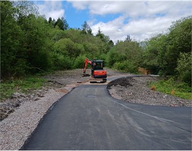
This week, Rhondda Cynon Taf Council confirmed that construction work on the final section of the 10km walking and cycling route between Ferndale and Tylorstown is nearing completion, with the final link expected to open by the end of May 2026.
The Council described the project as a “major investment” funded through the Welsh Government’s Active Travel Fund, designed to provide a dedicated pedestrian and cycle corridor from Maerdy to Tylorstown.
But for many residents, the announcement has reopened frustration over what they say the Rhondda Fach was originally promised — a full relief road running from Porth to Maerdy to tackle decades of congestion along the A4233.
Original Plans Included Major Relief Road
Historical planning documents show that the original vision for the Upper Rhondda Fach transport corridor was far more ambitious than the active travel scheme now being delivered.
Under Rhondda Cynon Taf’s Local Development Plan (LDP) up to 2021, two major highway proposals were identified:
- NSA 20.2 — Extension of the Porth Relief Road to Maerdy.
- NSA 20.3 — A further extension from Maerdy to the A4061 Rhigos Road.
The plans themselves stemmed from earlier Mid Glamorgan County Council transport strategies and were intended to extend the existing Porth Relief Road — completed in 2006 at a cost of around £45 million — further up the valley to ease chronic traffic congestion.
At the time, the Porth-to-Maerdy phase alone was estimated to cost more than £105 million.
From Relief Road to Cycle Path
Although the route was initially safeguarded within the Local Development Plan, the road scheme was eventually abandoned.
Instead, the former railway alignment through the Rhondda Fach has now been repurposed as the Rhondda Fach Active Travel Route — a shared-use path for walking and cycling.
Residents opposing the change argue that while cycling infrastructure has value, it does little to address the daily traffic pressures experienced throughout the valley.
Many point to regular congestion through Porth, Ynyshir, Wattstown, Ferndale, Stanleytown, and Tylorstown, particularly during peak commuting hours, along with concerns about emergency access and the long-term resilience of the transport network.
Critics also note that the upper valley remains heavily dependent on the A4233 Maerdy Mountain Road toward Aberdare — a route that has suffered repeated closures and stabilisation works in recent years due to landslips and storm damage.
Inspector Removed Further Road Extension
The second proposed phase beyond Maerdy toward the A4061 Rhigos Road was formally deleted from the Local Development Plan by the Planning Inspector in 2011.
The Inspector concluded there was no defined route, no identified funding source, and no existing railway corridor that could be reused. Concerns were also raised that continuing to safeguard an undefined route could “blight” communities and property owners across the area.
As a result, the wider strategic road proposal effectively disappeared from future transport planning.
“The Traffic Problems Remain”
For many residents, however, the fundamental issue has never gone away.
While the Council celebrates the near completion of the active travel route, some residents argue that the Rhondda Fach still lacks the infrastructure investment needed to properly address traffic congestion and connectivity issues affecting the valley’s communities.
The debate is likely to continue as the final phase of the walking and cycling route officially opens later this year.
Related Posts

Consulting on next phase of Relief Road through the Upper Rhondda Fach as far as Maerdy the A4233? Forget that it is now the proposed walking and cycling route

Progressing the new walking and cycling route through Rhondda Fach

Plans for the Upper Rhondda Fach Relief Road scrapped by Labour
