Stop Ynyshir Wind Turbines
Taken from Facebook,
I’ve been a bit quiet on here recently, so apologies. That said I’ve not taken my eye off the situation.
We know planning has been granted a few years ago, however many of the conditions applied to the planning application have not been discharged. The most significant of which being drainage.
Looking back at the original application, we know Rhondda Cynon Taff Council said an EIA (Environmental Impact Assessment) was not necessary. In one of the documents on the online portal:
“I refer to your letter dated 18th December 2014 requesting an EIA screening opinion in respect of the above-mentioned proposed development……
“….it is considered that an Environmental Impact Assessment would not therefore be required for the proposed development.”
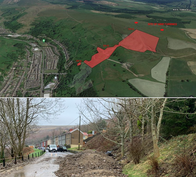
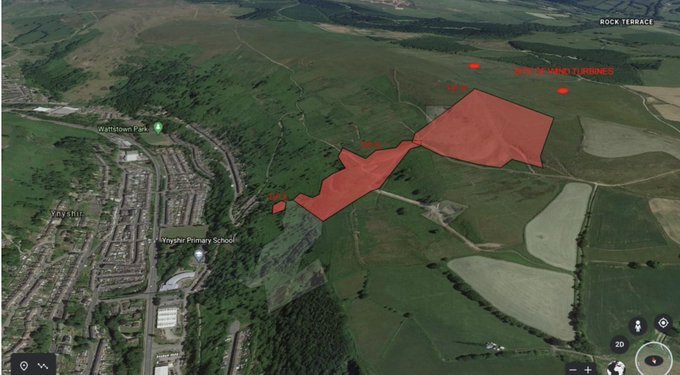
In my view this was not a great decision. The proposed development is directly above and 200m way from a collection of coal tips which are category D – the highest risk category. An EIA would have considered much more than just ecology and should have if done properly, picked up on the proximity of these tips and the streams and issues which appear at the hillside underneath the coal tips, from the plateau above. The same plateau where planning has been granted for the wind turbines.
Why is this a potential issue?
During the construction phase, there will be a significant amount of disruption to the upper plateau, which will introduce thousands of tonnes of trackway to gain access, thousands of tonnes of concrete as foundation and so on. Permission is granted for the foundation and trackway to remain in the ground forever, even though the turbines are only there for 20 years (unless permission is granted again in the future). To see the impact the construction can have, we only need to look to the Republic of Ireland. A huge peat bog disaster in Meenbog (Donegal: Peat landslide linked to wind farm raised in Dáil – BBC News) in 2020 and Derrybrien where the Irish Government are have paid millions to the EU in fines (Ireland fined €5m plus daily penalty of €15,000 over landslides at Galway wind farm (thejournal.ie).
How could this impact the underground water courses and this coal tip, which is in the highest risk category?
Simply, we don’t know. An EIA was not required, so it has not been investigated. That’s why we need to hold our Council to account when it comes to the drainage condition which has yet to be discharged. The drainage needs to take into account the coal tips and the underground watercourse. The land is owned by the same person, so if it were to go ahead, wouldn’t it be right if they invest in making this coal spoil safer prior to construction?
So far these category D coal spoils directly below the proposed development have not been considered.
We all know a few houses were flooded on Heath Terrace in February 2020, as well as a significant landslide. There have been some incidents of flooding since. Around 8 properties on Heath Terrace were demolished due to flooding and land slippage in the 50s any small change in water flow could be catastrophic.
Three footpaths are closed below this development due to Feb 2020 flooding: Upper Wattstown to Ynyshir, Ynyshir to Porth and the Llanwonno Road bridleway.
Coal Tip Reports from the 1970s
We are incredibly fortuitous to have insight from two NCB Coal Tip inspection reports on Ynyshir Lady Lewis Coal Spoils from 1970 & 1974. They are available from the Glamorgan Archives (reference D1617/24 & D1617/25), which state:
‘The coal spoils overlie both the Brithdir Rider and Brithdir Coal Seams.
The uppermost non-porous seam of coal, the Brithdir Rider is overlayed by fractured sandstone. A spring line may well develop where the junction of an overlying permeable and an underlying impermeable horizon along the hillside. Thick beds of jointed weathered and hence permeable Pennant sandstone overlie the impermeable rock types associated with the Brithdir Rider and Brithdir seams. Both are potential spring lines, and the greatest activity would be expected along the crop of the Brithdir Rider because of the very wide nearly flat catchment area of the overlying sandstone. The easterly dip is very low and will not significantly aid drainage of water to the east away from the tip site.’
The upper coal tip is banked against the Brithdir Rider coal seam and the lower is banked against the Brithdir coal seam, on a very steep slope.
It also refers to around 20 properties at risk in Ynyshir and to the construction of a proposed school, Ynyshir Junior School nearby.
Now, in short. The coal tip was a threat to those houses below in the 1970s. With greater rainfall, it poses more of a threat. Taking away grass, vegetation and water soaks on the plateau above this hill can only increase the amount of water entering the tips below to the west.
The NCB changed the watercourse in the late 60s and early 70s, to take some of the streams which are formed from the springs underneath the coal tip complex, both to the north and to the south of the tips. The northern stream is at the top of Llanwonno Road, which since flooding a number of houses in 2020 has been re-constructed to the tune of £300,000. The southern stream is next to Ynyshir Junior School.
During the 70s the Halcrow consultants, commissioned by the NCB came up with a schedule of maintenance that they would undertake periodically. Such as, every three months:
- Inspect all culverts, catch pits and manholes in the area of the tips and, where necessary clean out and repair.
- Inspect all open watercourses in the area of the tips and, where necessary, clean out and reinstate.
- Inspect the tips and adjacent areas to see whether any new issues or seepages have appeared since the previous inspection. Note also any alteration inflows.
In 1989 the NCB sold the land to the current owner, who also owns the land where the proposed turbines.
Since the Tylorstown coal-slide in 2020 the Welsh Government has been consulting on changing the law on coal tip responsibility. This change won’t happen in the next couple of years. As the law currently stands, the Local Authority will have a site walkover of high-risk tips every 3 or 6 months. They make recommendations to the owner on improvement which should be made. The owner does not have to implement these recommendations. So the work the NCB used to carry out, since being sold in 1989 is no longer enforced.
To not consider the underground drainage, the coal tips, the accumulative amount of coal extracted on the land directly below the coal tips and the proposed development would be a huge oversight.
In a proposed development of Wind Turbines in the Ogmore Valley, following an EIA, many of the locations of the wind turbines were modified due the level of coal extraction below the site. From the Halcrow NCB tip reports, we know the area of the tip complex and the area of the proposed Wind Turbines has an accumulative extraction of between 20ft and 40ft. A significant level of substrata removal.
In the last few weeks, the development company has started to submit requests to the Council to discharge various conditions. We have not yet seen any documentation regarding the drainage.
RCT Council has one opportunity to redeem itself and the anxiety it has unnecessarily inflicted on residents and this community by approving this development. Work cannot commence on this project until drainage has been approved. With a Category D (the highest risk) coal tip below, how can they possibly approve drainage for this development?
Please share from Stop Ynyshir Wind Turbines 2020 – Public Page